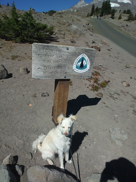
mile zero.
I was feeling like I had to stop by the ranger station in ZigZag, and they are closed from noon to 1:00, so I got there around 12:40 and I took advantage of the down time to change and do a little messing around with packing stuff, and sharing our first apple with Kirby.
I bought a map, which ended up being one of my smartest decisions of the whole trip. Then, up to Timberline.
Filled up my pack, annoyed that it would barely close, and with Kirby on the leash, headed out right around 2:00 PM.
One of the first people we met was a woman with an overnight pack. I asked if she was doing the Timberline Trail, but no, she is through-hiking the Pacific Crest Trail, which is the same trail for about five miles. We chatted for a few minutes; she was pretty interested in my camera bag, and I was a little abashed that her pack was about half the size of mine, and then took off.
We ran into a fair number of people, although not nearly as many as you’d see around Paradise. A few dogs, including a standard poodle.
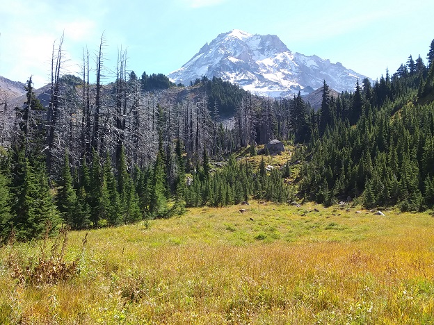
We dropped down into Zigzag canyon, where we stopped and had our bagel, and Kirby resolutely refused to eat any dog food. Then, up the other side.
My first decision was whether to take the Paradise Park loop trail, or stay on the TT. Looking at the map, I guessed that the scenic part of the loop trail was lower down, so I stayed on the TT/PCT, and I think I made the wrong decision from the point of view of scenery. Next time, I guess.
Much of the hike is through trees, but you do break out into dramatic vistas, like the Paradise Branch Canyon, where I got a little lost. The hillside there was quite sandy, and there was a trail heading down the side of the canyon where I went for a few minutes before realizing my mistake and heading back up to find the correct trail.
From here it’s a long, gradual downhill slog – most of the first day was more down than up, in fact – to the Sandy River. I passed a guy on the trail who was also on the TT, heading the same way as me, but who hadn’t done it before either, so I couldn’t cadge any beta from him. I put Kirby on his leash before approaching him, just in case. I didn’t run into anyone who didn’t like dogs, but it always seems prudent to be polite.
One surprising thing (to me) was the number of rhododendrons I saw in the forest. I know it’s a native plant, and I guess it’s common in the Olympics, but it seems odd to me to see them growing in the woods.
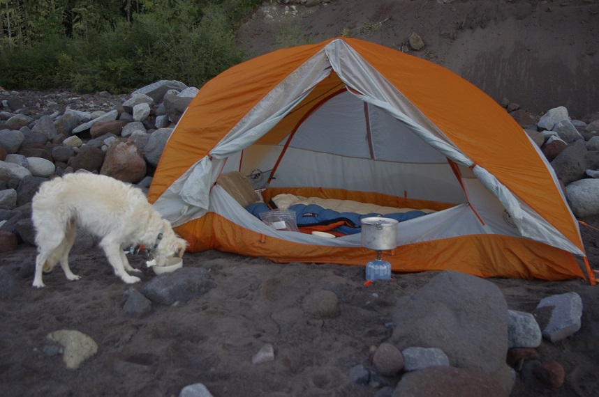
I made my first camp by the Sandy River. It’s a big wide rocky river flood plain, at least 100 yards wide, and the Sandy River looked a bit difficult to cross with Kirby, so I stayed on the south side, hoping that in the morning the river would be lower. I camped far from the main branch of the river on account of the noise, near a side stream which had the advantage of not being at all silty – the Sandy was pretty milky. No point in clogging my water filter on day one.
So I pitched the tent, fetched water to filter, and made dinner, while Kirby wandered around, going alarmingly far a few times. There was a group of people camped a ways upstream, and I was worried that he’d go bother them. It was my first time using the new stove from Fred, and it works pretty well, except that it feels a little tippy. Normally the Whisperlite stove feels quite stable; this one has a much smaller grate to hold the pot, and I worried that Kirby might bump into it.
Dinner was the most insipid Pad Thai I’ve ever had, but there was a lot of it. I mixed some of it into Kirby’s dog food, and he made quick work of it, and actually ate some more of his food as well, but he was pretty focused on the smell of the Pad Thai bag.
Then, I filtered some water to fill my hydration bladder (I hadn’t drunk much, it was actually cooler than I expected, and I sweated very little over the day.)
The guys up the river appeared to have a fire going, and I thought about taking Kirby up there on the leash to go say hi, but decided against it, for no good reason but my typical timidity.
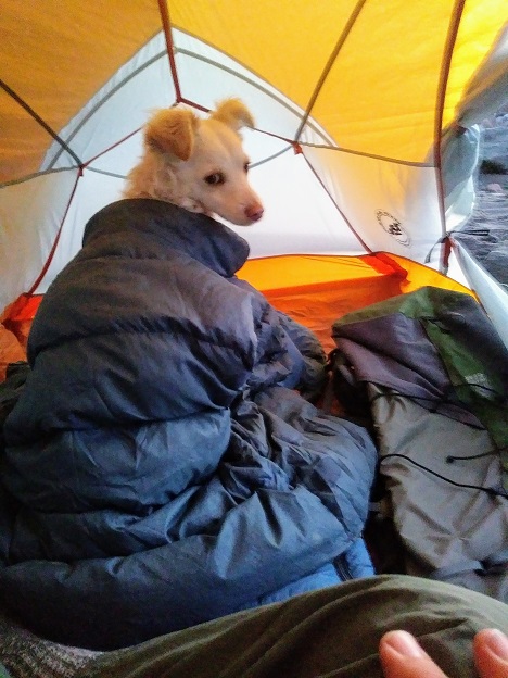
Bedtime was my biggest area of concern. It was chilly down in the river valley; I had my down coat on, and at one point, I thought I saw Kirby shivering. So when I coaxed him into the tent, he plopped right down on my sleeping bag, and stared intently out the door opening into the gathering gloom.
I ended up emptying out my pack, and using it as sort of a sleeping pad for him, to at least give him some insulation from the cold sand, and making a nest for him with the down jacket, and putting the down vest over him. He settled right down to sleep.
So, I settled down with my headlamp and a library copy of The Moviegoer, which I’m still trying to appreciate. My headlamp was fading, so I had to swap out the batteries, using the flashlight from my phone. Technology was troublesome, this trip. I read for about an hour, then put myself to bed.
Day two, Tuesday, Sep 25, 2018
I did a lot of tossing and turning in the sleeping bag, as usual, and don’t know how much I really slept. In the night the moon came out up over the south rim of the valley, and lit up the tent quite a bit. If you envision a car parked about 50' away with its headlights on and pointing towards the tent, that will give you a general idea.
At some point in the early hours, Kirby got out of his down vest comforter. I worried, of course, that he would get cold and wouldn’t be able to figure out how to get back under it, but decided that he probably wouldn’t go hypothermic on me, and let him be.
I got up around 6:30, when it got light enough to start to see what I was doing. I was gratified that I needed to take a long pee, since hydration is always a concern. Kirby was quite perky, trotting around the rocks, wanting to play.
Tragically, I didn’t bring along any milk for my coffee, so I had a cup of black Starbucks Via, Christmas blend, and it was okay. Then two packets of instant oatmeal with some raisins mixed in, and a little brown sugar. Again, I saved a few tablespoons full for Kirby, mixed in with his dog food.
My routine is to use the freeze-dry food bag with its zip lock seal as my garbage bag, and so I stuffed the coffee plastic and the oatmeal envelopes in there – Kirby continues to be really intent on the smell of that Pad Thai. The tent fly was absolutely drenched in the morning. I assumed it was just heavy dew, but my Tevas were also wet with standing water on them, so maybe what’s going on down there is the river generates some mist which then settles onto everything. Certainly it didn’t rain in the night.
I tried to take a photo of the mountain in the early morning, but the camera didn’t work – the batteries were dead. So I dug the backup set of batteries out of my bag and replaced them, and… same thing. It’s kind of frustrating, since it worked fine yesterday. But a few years ago, my last Pentax stopped working in just this way.
I got packed up, after shaking the tent fly out really energetically to get as much water (and sand) off as I could, and the tent as well, and we were on the way by around 7:40.
The Sandy River was indeed much lower and easy to cross. Kirby doesn’t really like getting picked up, but I grabbed him, and with the hiking pole had no trouble hopping across.
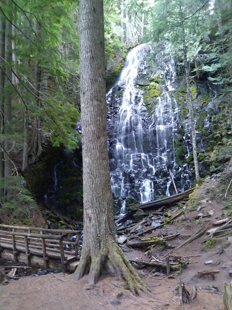
First stop was Ramona Falls, half a mile up the valley. It’s quite pretty, a wide waterfall cascading down a rock face, and there was some horse corrals and fences set up there. Apparently the TT was constructed by the CCC to be able to accommodate horses, but these days there’s enough erosion on some sections that it’s not safe. I hadn’t seen anything like that so far.
(Socio-political note: the Civilian Conservation Corps, or CCC, was one of the agencies set up during the depression by the Roosevelt Administration in order to provide jobs for the armies of unemployed. They did a tremendous about of work that we're still benefiting from: reforesting millions of acres, building roads and bridges, building the Timberline Lodge and Tilly Jane Hut, campgrounds in places like Millersylvania State Park... the list is gigantic. You can read about it here if you're interested.)
Then, up the hillside over Yokum Ridge, and down the next valley, called the Muddy Fork, where there are three different streams to cross meandering through another wide boulder field.
Yokum Ridge is one of the true hard-man winter climbing routes on Mt. Hood, but down here, it's just another glacial ridge.
Kirby seems to be getting the hang of following a trail. Generally the TT is as easy to follow as a sidewalk, but when it meanders through broad rocky streambeds, it’s not nearly so easy to follow, and cairns are infrequent. I assume Kirby is following his nose, because there were a couple of times on this crossing that he chose what turned out to be the correct path, while I messed around with the wrong one.
Then up the next ridge. Way up ahead I could see a trail crossing an open spot in the trees high up on a hillside. Turns out that’s Bald Mountain, and there is a cutoff that you can take to avoid going around the mountain (and the sunny slope) and saving, according to the map, 1.2 miles. I thought about taking the cutoff, but then decided I’d regret it, as I was already regretting my Paradise Park decision, so I took the long way, and it was delightful to walk in the sun for a while. We ran into couple of women and their dog Olive, a nine-month-old black lab, and Kirby raced up and down the trail with Olive a bit, and we pressed on.
Fewer views of the mountain today, and it continued chilly. I kept my sun hat on, not because of the sun, but to keep warm. I kept waiting for a nice sunny spot to stop for our first lunch (the apple) but it just didn’t come.
We passed a guy with a day pack, and then probably 15 minutes later I just gave up and climbed up the hillside a bit to a tiny puddle of half-sun, and we had the apple, and Kirby ate some of his dog food, too. I cut little pieces of apple off with my knife, and at the end I cut up the core and extracted the seeds (probably overly fastidious, I know, but apple seeds are supposed to be poisonous) and fed him the core as well. He made a dive for the stem when I tossed it; he’s got even more of a sweet tooth than I do. I gave him some of his dog food, and he actually ate a fair amount. I was pretty surprised, and was seized by guilt that I was starving him.
While we were sitting there, the guy we’d passed came by, earbuds in and head down, and a bit later three hikers, looking like retiree Mountaineers, passed by as well. After we finished up, we headed on out, and about ten minutes later ran into the three, sitting in a beautiful sunny hillside. So I stopped there and chatted with them, and studied my map some, and they told me about what was ahead. In particular they mentioned Elk Meadow, a lake down on the SE side of the mountain, that’s beautiful and worth camping at if I had time.
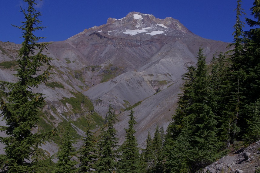
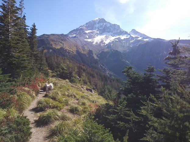
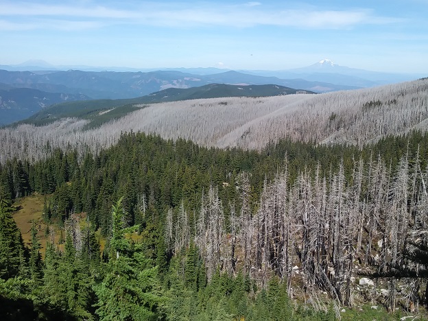
On again. Things opened up a bit; we apparently passed Cairn Basin, which I missed, and into Elk Cove, which is pretty, and then into the burned over areas. I wasn’t aware that the burns were so extensive; I bet about 1/5 or so of the trip, around the northern end of the mountain, was burned forest, with dead trees standing. It was kind of pretty and lighter, up close, but looking off into the distance as the expanse of burned trees it’s a different feeling.
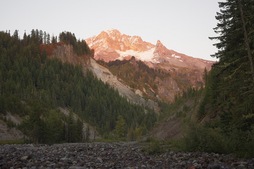
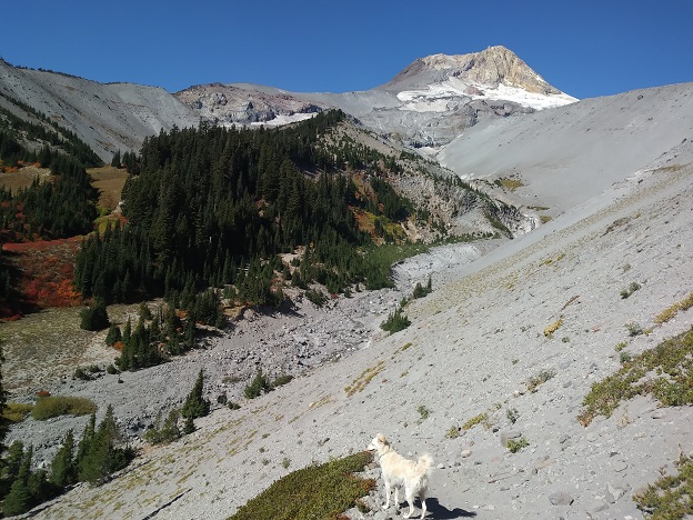
Mt. Hood from the north.
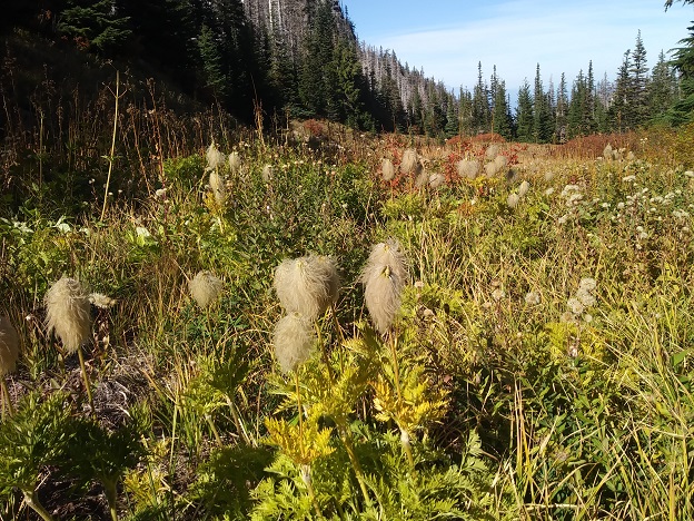
Mountain Anemonies, far better known as "mouse on a stick."
Then we stopped on some rocks in the sun for our second lunch, the bagel and some more dog food for him to reject. Then on. The plan was to stop at Cloud Cap, which shows that there’s a campground there. It was a good feeling to come around a bend and see the Cloud Cap Inn there perched on the end of a ridge, only about half a mile away. “I’m making really good time!” Several hours later, after going in and out of a number of valleys, crossing the Coe Branch, where I had a difficult time finding the trail on the other side, back up again, and meeting a woman (reminded me a bit of Gillian) who was doing the TT from the other direction, then came face to face with the deep gorge that is the Reid River.
It’s not the Grand Canyon or anything, but it’s a few hundred feet deep, and my feet were tired (I had a blister on the ball of my left food, which felt like stepping on a tack with each step) and I was just tired. Going down isn’t much easier than going up, and looking across at the other side at the switchbacks marching up the hill, it was pretty daunting.
You descend down, down, down, into the bottom of the gorge (it’s not a valley) and then kind of scramble down on the rocks at the riverside. ALl other obstacles aside, it would take a LOT of work to make this section accessible for horses.
Upstream a little way is a couple of logs that are the crossing; again I picked up Kirby and carried him over, then we followed the long switchbacks that work their way up the lower gorge, followed by shorter ones further up. At one point I felt like I had to sit for five minutes and give my feet a break. Kirby just kept poking around, looking for pikas or birds, or whatever he was chasing, but it was awfully nice sitting there in the sun, with my feet out, and after a couple of minutes he came down and sat next to me, eyes half closed, like he does.
Then up again, and eventually to the top of the ridge, and the hike over to the Cloud Cap campground. Where tent spots are $22 a night, and the sign pointing to “water” points to a disassembled spigot because the water needs treating. “Bullshit” I thought, and decided to press on half a mile to the next spot, Tilly Jane campground, passing a couple of decent-looking camp sites on the trail.
Tilly Jane is $21 a night and has no water either. So, back almost to Cloud Cap (close enough to see the pit toilet building) and a decent little spot right off the trail to pitch my tent. Dropped everything and took the water bags back to the creek, and eventually got them filled enough. So, I logged an unnecessary extra mile.
While we were there, I heard some very loud pounding on the ground, which I thought was horses at first, then realized they must be elk. (They couldn’t have been horses, because there were some trees blocking the trail at around chest-height, so it’s hard to see people negotiating that on horseback.) Kirby was riveted, staring in their direction. He wasn’t on leash, of course, and I worried about him chasing after them, but he just stood there staring intently in the direction (towards Tilly Jane) where the hoofbeats had come from. (Do elk have hoofs? Or feet?)
I was kind of worried that someone would come over and tell me I had to pay a fee, but no one ever did. There were a couple of cars parked in the campground parking lot in the evening, and they were still there in the morning, but I didn’t see any tents or trailers, so I don’t know what was up.
I cleaned up the site, and pitched the tent, and made dinner (New Orleans beans and rice, not as bad as the Pad Thai, but more tasteless) while Kirby stood there on the trail, staring intently towards the camp ground. Maybe there were people there or he smelled food, or something, but he was on high alert.
When I went to light the stove, the lighter failed. It was the silly old lighter from my Amsterdam trip (I forget now why I even bought it) but it gave one little half-flame, then that was it. Thank God I’d found and packed a backup lighter. Technology was not my friend this trip; I really need to add some waterproof matches to my black bag.
It was weirdly quiet that night. Last night by the river there was the constant sound of water rushing, of course, but tonight was so quiet that we could have been camped inside an abandoned shopping mall. I heard a couple of airplanes high overhead, but nothing else, and the quiet was more distracting: the slight rustle of the tent fly in the breeze made me wonder if there was an animal in the brush. It was much less cold, as well, which was a positive thing.
Wednesday, Sep 26, 2018
Morning, day 3. Our second morning on the trail.
I did my cup of coffee, and the two packets of oatmeal (one was this “dino eggs” stuff that Candice bought at some point for Sawyer; it was about 80% solid sugar by weight, I think; I gave Kirby most of the dino eggs after picking out all the raisins, which are supposed to be bad for dogs.) Mixing cooked oatmeal with his dry dog food works pretty well. I’d brought a packet of instant gravy that I had planned on using to doctor his food, but never used it.
One surprise is that this morning there were mosquitoes around, buzzing at me. I dug out that “new” bottle of bug spray and squirted it liberally around my neck, ears, etc.
Again, up at 6:30, on the trail by 7:30. It was noticeably warmer, which made it easier to get going, and I felt good about the tent being dry. As I was getting ready to go, I saw an even nicer and more obvious tent site not ten feet from where we were. I guess I’d missed it in the dusk.
We headed up the TT, up the hill, which I wasn’t that happy for, but in half an hour we were into a different world: a scrubby pine forest, followed by the dry, arid plantless slopes of the east side of the mountain. It feels like the area we’d just come from, the Cloud Cap and Tilly Jane campgrounds, were a kind of slum, a dirty, sloppy insult to the trail. “White trash” is the phrase that comes to mind. Maybe part of it was my annoyance at the difficulty of traversing the Reid River (I had heard that for several years the crossing was out; I see now that it would have been an unavoidable obstacle if that were the case.)
But now, up and out of the trees, in the sun and glorious blue sky, and the mountain looming up on the west in all its glory, it felt like a new start.
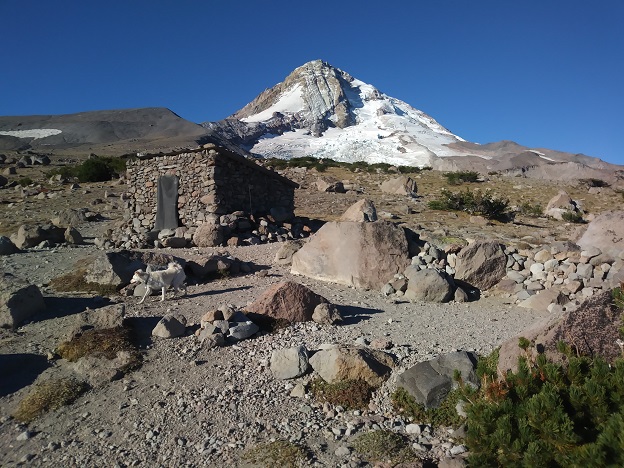
We passed a trail that headed up the hill, and when I looked, I saw that it was the Cooper Spur trail, heading up to the rock shelter. So I dumped my pack and followed Kirby up there. I’d come by here with Oleg a few years ago when we were attempting Cooper Spur (in December a few weeks after I’d gotten the Hyundai) and it was fun to see it again. It’s awfully small, smaller than I remembered; I don’t think more than about three people could sleep in there comfortably, and of course there’s no water anywhere nearby. There are a few tent sites around there, with rock wind walls, but it would be a pretty windy place to camp.
I zipped off my pants legs, and for the first time since ten minutes into the hike on Monday, I took off my long-sleeved blue shirt, and hiked in just a t-shirt. More stuff to cram into the pack.
Shortly after, we met a couple of guys – running. They were running the TT; they’d started from Timberline around 6:00 AM. I told them about the Reid crossing, and they were on their way. As I looked back to watch them, there was a magnificent view of the two of them running up the trail, with Mt. Adams in the background, their bright colored clothes contrasting perfectly with the sere landscape. I didn’t have time to get my phone out for a photo before then went behind a rise, unfortunately. On we went. Apparently the high point of the trail is around here, but I didn’t notice.
We crossed a tongue of icy snow, and Kirby got to lick at it, but he wasn’t much interested in the little chunks of ice I chopped out for him with my knife. Then we passed another little valley with some water running through it, so Kirby got his hydration.
When there is water, I have to stop and wait, or he won’t drink. It’s as though he won’t drink if there’s anything else at all to do, so I have to be careful to not make any moves in the direction we’re heading, just stand there (or better, sit) and wait for him to finish his drinking. I worry a lot about his not getting hydrated, partly because I don’t know how I’d tell.
A bit further, we came to a hill where a dozen or more crows where flying around, and a couple of them were up there, perched on this rock. I was intrigued, so I put down my pack and headed up there with Kirby. There was nothing obvious going on, no dead animal that they were eating, but it was kind of curious.
These were crows, not ravens. A raven flew over us yesterday by Cloud Cap, and I was reminded of how loud their wing sounds are. I still can’t distinguish them by sight, but they sound and behave very differently. To my ear, ravens sound like kids trying to imitate a crow.
This leg of the trip was about 3.7 miles, from CC to the cutoff to Elk Meadows, and I figured that after that, it was just a walk over to Timberline. Wrong again. Very wrong.
I met this guy with a day pack who had just come up from Elk Meadows and said it wasn’t anything special. He said he’d left the parking at 7:00 – it was now 10:30 – and I assumed it was the Timberline parking lot, so it was going to be a piece of cake. Then, a bit further, after passing around Gnarl Ridge, and wrapping around to the trail heading down to Elk Meadows, where we stopped for our apple. Then, on we went.
This leg of the trip is longer, and harder, than I’d banked on. Part of the problem is the way the map was folded so that the trail goes behind the fold, but this part was hard. At one point, I saw the top of a ski lift in the distance and thought: that’s Timberline right there – I’m not ready for my trip to be over yet! But it wasn’t, and it wasn’t. We still had to contour around Pea Gravel ridge, a quite prominent feature on the mountain that I’d never been aware of. Then, you eventually get to the Mount Hood Meadows ski area, which is where that ski lift structure was. You cross through a bunch of bowls, each more beautiful than the last. The bear grass and mountain anemone (mouse-on-a-stick) is thick here; a few weeks ago it would have been pretty as Paradise.
We sat there for 20 minutes or so, and didn’t see another person, in what was probably the most beautiful single spot on the entire trail. Then on, into the ski area, and we passed an older woman hiking along the other direction. This was the fourth person, and the last, we saw all day before reaching Timberline. There were by my count 11 people was saw yesterday. Not exactly overtravelled.
On we went, and I was getting beat, and then we passed a sign that said Timberline 4 miles, Cloud Cap 9 miles. Okay, we have four miles of moderate forest hiking. Nope.
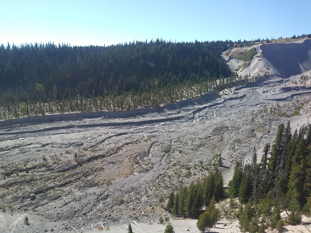
The most impressive obstacle of the hike was the White River, but it looks a lot worse than it is. The river flood plain is probably a third of a mile across, hard to follow the trail markers and more importantly, it was initially difficult to figure out where, on the other side of the river, the trail continued. Back on went the Tevas, and I portaged Kirby across. The stream was only about ten feet wide, and I could have easily gone across it barefoot in the sand.
Over the hikes we’ve gone on, Kirby has gotten increasingly good at the techniques of hiking – following trails, maneuvering over boulders, and so forth (and eating snow.) And this trip, he started being a lot better about finding his way over small streams, either leaping gracefully over rocks, or once actually stepping into some shallow flowing water, to get across without my help. Once, he even crossed a log, although he slipped towards the end and had to leap to safety. This time, of course, he wouldn’t have been able to cross it, so I had to carry him.
Over the other side, and I found the trail heading up the west side – there were actually two, about 200 yards apart – and then stopped, again, to put my boots back on. Last time I’d hiked in my Tevas for half a mile or so; this time there was too much sand for that.
On, and on. I came to the sign marking our confluence with the PCT, which meant we were only 1.5 miles out, about half an hour earlier than I expected, and that was nice. Well before this there was phone service, so I texted Candice to let her know we were okay. I’d thought there would be service at Cloud Cap, but there wasn’t. In retrospect, there probably was at Bald Mountain, since it was facing Portland, but I didn’t check.
The trail goes over a sandy area, and there are posts in the ground periodically to help with routefinding. I was happy to see Timberline lodge, and then dismayed to see ANOTHER deep ravine between us and our objective. The trail actually goes north for a bit, up hill, past Timberline, before dropping down into the moderate ravine and up the other side. I missed the spot where it drops down because it wraps behind a rock, and the trail appears to keep going up the hillside; I thought this was just another photo spot. Eventually, the trail seemed to peter out, and I was getting more and more annoyed, so I just headed back down the hill where I could find a good place to descend and connect to a trail n the other side, and that’s when I saw the correct trail. It would have been much easier to follow going the other direction, except of course that there are a lot of trails kind of braiding around.
Then, finally to the car, at 4:30. I found my key in the black bag (my regular dread is that I’m back at the car, but the key is missing), packed the car back up, coaxed Kirby into the back seat, where he didn’t seem at all eager to get in, and down the mountain.
Around Rhododendron I had to pull over briefly because there was a fire, right off the road on the south side. There was a fire truck there, and two more racing up HW 26 toward us, turning off the highway right there. I had seen some smoke in the distance before, and could see the flames through the trees, but couldn’t really tell if it was a forest fire or a house fire. I stopped at the grocery in Welches for some water, a sandwich, and some dog treats for Kirby, and then in Sandy for gas, and then just drove straight home. Interestingly, the trip down there Monday AM was about 5 hours, according to my phone, and only a little over four on the way home. Got home a bit after 9:00. Kirby drank from the water bowl on the front porch, which made me feel a little guilty.
I left absolutely everything except my phone & iPod in the car for tomorrow, went up and showered, and to bed. Weirdly, I wasn’t that sleepy, and was up again at 6:00, wide awake.